Log in
All resources
Create a design
145 Free Artworks of Maps Of Straits
bibliothèque nationale de france
eran laor cartographic collection
jodocus hondius ii, nova totius terrarum orbis geographica ac hydrographica tabula, 1636
world map
national library of israel
jodocus hondius ii
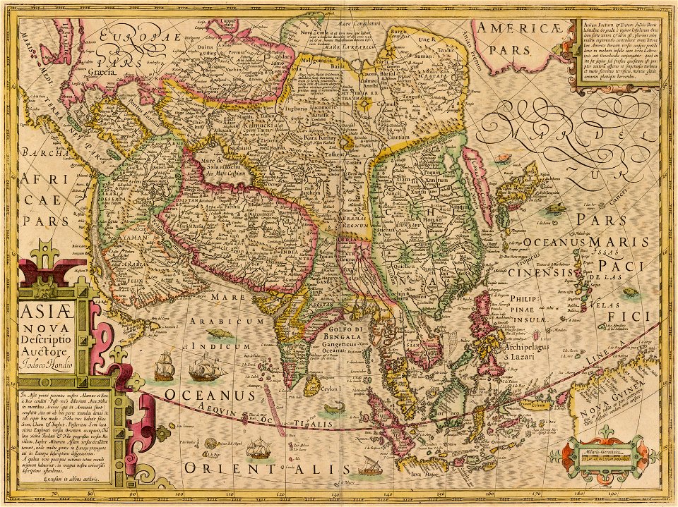
strait of anian
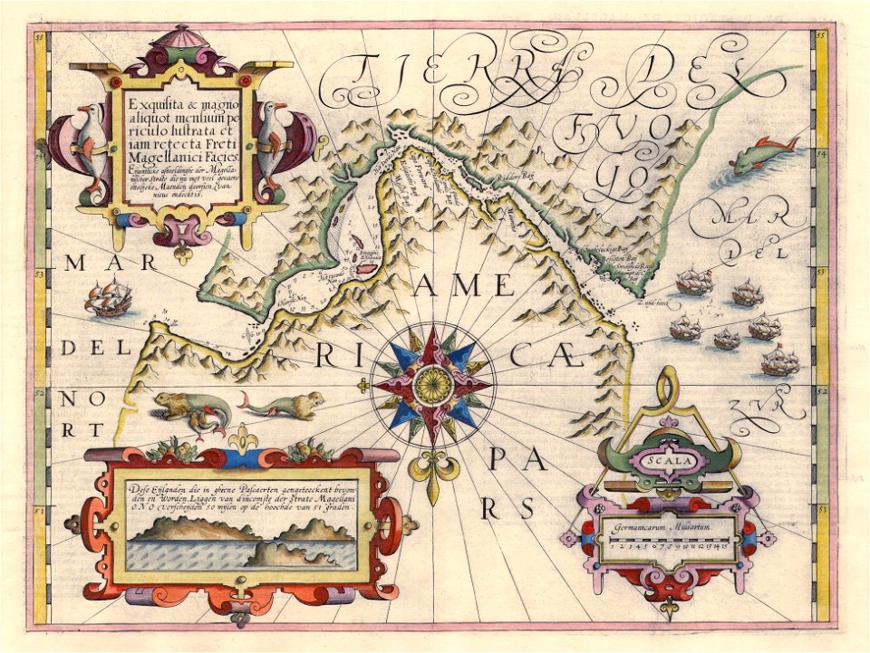
17th-century maps of the strait of magellan
dutch-language maps
maps of the north pole
third voyage of willem barentsz
16th-century maps of the arctic
third voyage of willem barentsz
history of dutch sea fisheries
third voyage of willem barentsz
history of dutch sea fisheries
third voyage of willem barentsz
16th-century maps of the arctic
third voyage of willem barentsz
16th-century maps of the arctic
the voyage of the vega round asia and europe
third voyage of willem barentsz
overwintering on nova zembla by willem barentsz, 1596-1597
maps in the rijksmuseum amsterdam
overwintering on nova zembla by willem barentsz, 1596-1597
maps in the rijksmuseum amsterdam
19th-century maps of tibet
1850s maps of china
19th-century maps of the malay archipelago
19th-century maps of southeast asia
1704 in gibraltar
louis boudan
1560s maps of north america
paolo forlani
old maps of the united states
sanson maps of north america
maps of asia by mercator-hondius
qara khitai
18th-century maps of the sea of marmara
18th-century maps of the dardanelles
17th-century maps of the strait of magellan
1635 maps
18th-century maps of the sea of marmara
18th-century maps of the dardanelles
1680s maps of north america
hugo allardt
old maps of the strait of gibraltar
1762 maps of spain
old maps of the russian empire
1790s maps of alaska
18th-century maps of the strait of magellan
1700s maps of argentina
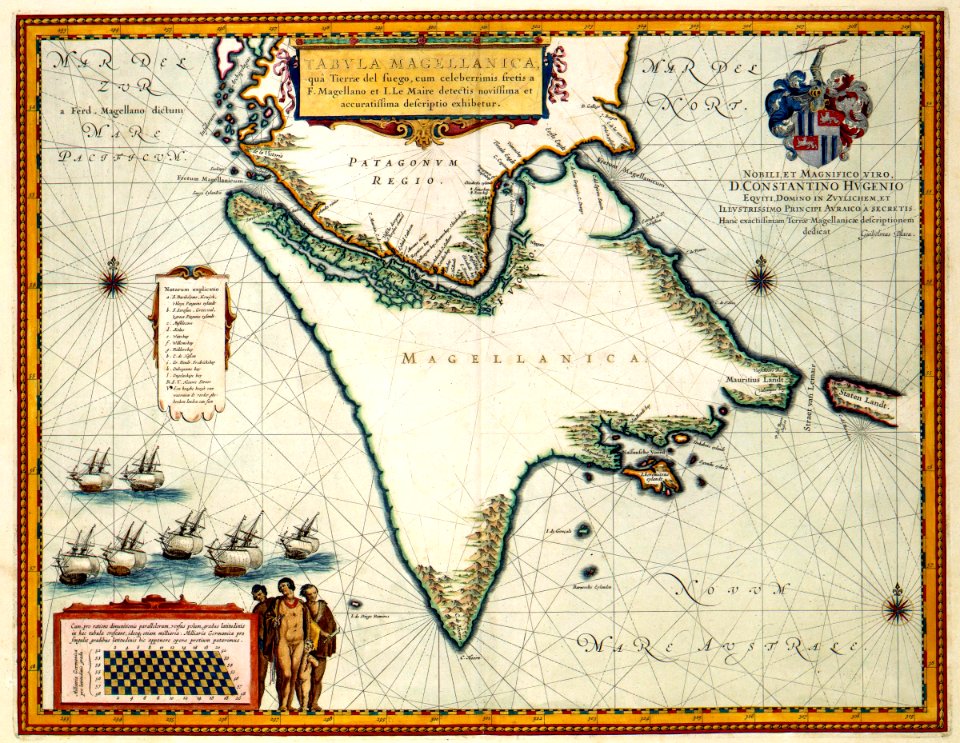
jacob le maire
1635 maps
maps of the magellan straits by lambert cornelis
old maps of the dutch east india company
maps by jodocus hondius
1628 maps
18th-century maps of the aegean sea
1780s maps of greece
17th-century maps of the strait of magellan
maps by nicolas sanson
propaganda map
1529 maps
maps of strait of messina
jean-pierre houël
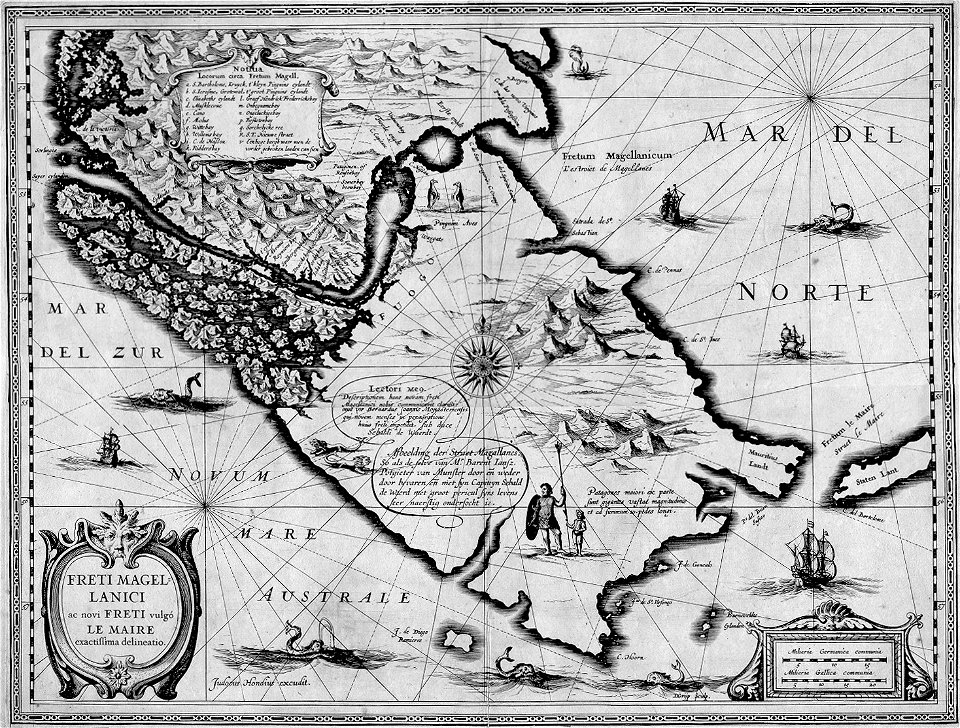
17th-century maps of the strait of magellan
maps by willem and johannes blaeu
media from atlas of mutual heritage on dutch east india company
portolan charts by willem and johannes blaeu
maps of the west-indische compagnie
1705
old maps of the bering strait
18th-century maps of siberia
carte de la mer mediterranée (1764) by roux
eran laor cartographic collection
maps of the magellan straits by lambert cornelis
bibliothèque nationale de france
maps by pieter mortier
maps from gallica
the bottom of the sea (1870)
maps of the strait of dover
old maps of the strait of gibraltar
hendrik de leth
voyages and travels to india, ceylon, the red sea, abyssinia, and egypt, vol. 2
henry cooper (engraver)
17th-century maps of the strait of magellan
maps by jodocus hondius
media from atlas of mutual heritage on dutch east india company
1665
old maps of siberia
erik palmqvist
old maps of the strait of gibraltar
hendrik de leth
maps of the magellan straits by lambert cornelis
context files from gallica
1860s maps of china
1863 maps of asia
maps by jodocus hondius
1628 maps
nieuwe en beknopte hand-atlas (1754)
old maps of the strait of gibraltar
17th-century maps of the strait of magellan
1640 maps of south america
old maps of the bay of gibraltar
18th-century maps of gibraltar
19th-century maps of the black sea
g. h. swanston
maps of the magellan straits by lambert cornelis
bibliothèque nationale de france
maps from the earth and its inhabitants, vol. vii
1884 maps of taiwan
maps by willem and johannes blaeu
1610s maps of the americas
old maps of the bay of gibraltar
18th-century maps of gibraltar
17th-century maps of the strait of magellan
maps by willem and johannes blaeu
maps of the magellan straits by lambert cornelis
maps in the library of congress
picturesque journey to the two americas, asia and africa
1842 in bolivia
map of the bosphorus strait by guillaume sanson (1665)
bibliothèque nationale de france
map of the bosphorus strait by guillaume sanson (1665)
bibliothèque nationale de france
jodocus hondius ii, nova totius terrarum orbis geographica ac hydrographica tabula, 1636
eran laor cartographic collection
18th-century maps of the mediterranean sea
1745 maps
maps of the strait of dover
cartes de franz schrader
jodocus hondius ii, nova totius terrarum orbis geographica ac hydrographica tabula, 1636
eran laor cartographic collection
jodocus hondius ii, nova totius terrarum orbis geographica ac hydrographica tabula, 1636
eran laor cartographic collection
jodocus hondius ii, nova totius terrarum orbis geographica ac hydrographica tabula, 1636
eran laor cartographic collection
jodocus hondius ii, nova totius terrarum orbis geographica ac hydrographica tabula, 1636
eran laor cartographic collection
maps of the history of morocco
empire of morocco
map of the bosphorus strait by guillaume sanson (1665)
bibliothèque nationale de france
map of the bosphorus strait by guillaume sanson (1665)
bibliothèque nationale de france
map of the bosphorus strait by guillaume sanson (1665)
bibliothèque nationale de france
18th-century maps of the malay archipelago
18th-century maps of southeast asia
maps of the magellan straits by lambert cornelis
atlas minor gerardi mercatoris (1621, maps)
city gates of calais
citadelle de calais
1740s maps of the world
maps by emanuel bowen
eran laor cartographic collection
pierre mortier
the british monarchy (1743)
maps in the british museum
old maps of the strait of gibraltar
a school geography (1898) by bird
maps by pieter mortier
maps from gallica
map of the strait of kerch by guillaume sanson
bibliothèque nationale de france
map of the strait of kerch by guillaume sanson
bibliothèque nationale de france
jodocus hondius ii, nova totius terrarum orbis geographica ac hydrographica tabula, 1636
eran laor cartographic collection
jodocus hondius ii, nova totius terrarum orbis geographica ac hydrographica tabula, 1636
eran laor cartographic collection
jodocus hondius ii, nova totius terrarum orbis geographica ac hydrographica tabula, 1636
eran laor cartographic collection
jodocus hondius ii, nova totius terrarum orbis geographica ac hydrographica tabula, 1636
eran laor cartographic collection
jodocus hondius ii, nova totius terrarum orbis geographica ac hydrographica tabula, 1636
eran laor cartographic collection
jodocus hondius ii, nova totius terrarum orbis geographica ac hydrographica tabula, 1636
eran laor cartographic collection
jodocus hondius ii, nova totius terrarum orbis geographica ac hydrographica tabula, 1636
eran laor cartographic collection
jodocus hondius ii, nova totius terrarum orbis geographica ac hydrographica tabula, 1636
eran laor cartographic collection
jodocus hondius ii, nova totius terrarum orbis geographica ac hydrographica tabula, 1636
eran laor cartographic collection
admiralty charts region b: england wales ireland english channel southern north sea
admiralty charts 1401-1600
maps from the earth and its inhabitants, vol. xiv
maps of the sunda strait
a history of land mammals in the western hemisphere (1913)
jodocus hondius ii, nova totius terrarum orbis geographica ac hydrographica tabula, 1636
eran laor cartographic collection
the comprehensive history of england (1876)
english-language maps showing history
eran laor cartographic collection
isaak tirion
map of the strait of kerch by guillaume sanson
bibliothèque nationale de france
map of the bosphorus strait by guillaume sanson (1665)
bibliothèque nationale de france
map of the strait of kerch by guillaume sanson
bibliothèque nationale de france
the comprehensive history of england (1876)
english-language maps showing history
old maps of tierra del fuego
description de l'universe
géographie générale; physique, politique et économique (1876)
old maps of the strait of gibraltar
1 - 100 of 145
Next page
/ 2